


tête des Chaudières

André Rigollier
User
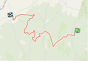

Length
4 km

Max alt
1518 m

Uphill gradient
272 m
Km-Effort
6.9 km

Min alt
1244 m

Downhill gradient
43 m
Boucle
No
Creation date :
2022-10-11 07:28:53.464
Updated on :
2022-10-11 09:14:05.206
1h44
Difficulty : Medium

FREE GPS app for hiking
 SityTrail
IGN / Geographical institutes
SityTrail Plus
The world is yours!
About
Trail Walking of 4 km to be discovered at Auvergne-Rhône-Alpes, Isère, Château-Bernard. This trail is proposed by André Rigollier.
Positioning
Country:
France
Region :
Auvergne-Rhône-Alpes
Department/Province :
Isère
Municipality :
Château-Bernard
Location:
Unknown
Start:(Dec)
Start:(UTM)
702929 ; 4985026 (31T) N.
Comments