


20221011-Pont de L'Arche Cool

doudet
User
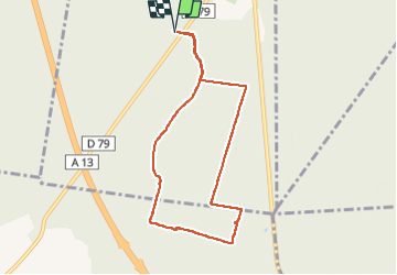

Length
7.1 km

Max alt
143 m

Uphill gradient
118 m
Km-Effort
8.7 km

Min alt
44 m

Downhill gradient
119 m
Boucle
Yes
Creation date :
2022-10-11 07:33:47.521
Updated on :
2022-10-11 10:53:50.35
1h57
Difficulty : Very easy

FREE GPS app for hiking
 SityTrail
IGN / Geographical institutes
SityTrail Plus
The world is yours!
About
Trail Walking of 7.1 km to be discovered at Normandy, Eure, Pont-de-l'Arche. This trail is proposed by doudet.
Description
Boucle A-R au départ du croisement de la D79 et de la route forestiere de Cobourg
Positioning
Country:
France
Region :
Normandy
Department/Province :
Eure
Municipality :
Pont-de-l'Arche
Location:
Unknown
Start:(Dec)
Start:(UTM)
365044 ; 5461463 (31U) N.
Comments