


Rosey

JacouBrijou
User

Length
16.6 km

Max alt
1057 m

Uphill gradient
713 m
Km-Effort
26 km

Min alt
455 m

Downhill gradient
714 m
Boucle
Yes
Creation date :
2022-10-11 06:34:46.844
Updated on :
2022-10-11 12:59:52.611
6h23
Difficulty : Medium

FREE GPS app for hiking
 SityTrail
IGN / Geographical institutes
SityTrail Plus
The world is yours!
About
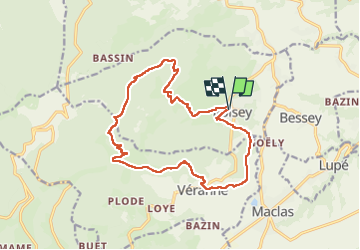
Trail Walking of 16.6 km to be discovered at Auvergne-Rhône-Alpes, Loire, Roisey. This trail is proposed by JacouBrijou.
Description
17 km dans le Pilat
Positioning
Country:
France
Region :
Auvergne-Rhône-Alpes
Department/Province :
Loire
Municipality :
Roisey
Location:
Unknown
Start:(Dec)
Start:(UTM)
630830 ; 5027307 (31T) N.
Comments