


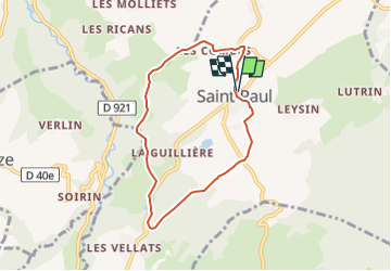
St-Paul-G1 courte-Boucles des Pins et de la manche

papou73
User

Length
6.6 km

Max alt
507 m

Uphill gradient
169 m
Km-Effort
8.8 km

Min alt
368 m

Downhill gradient
168 m
Boucle
Yes
Creation date :
2022-10-12 07:34:08.918
Updated on :
2022-10-12 07:35:48.413
2h00
Difficulty : Medium

FREE GPS app for hiking
 SityTrail
IGN / Geographical institutes
SityTrail Plus
The world is yours!
About
Trail Walking of 6.6 km to be discovered at Auvergne-Rhône-Alpes, Savoy, Saint-Paul. This trail is proposed by papou73.
Positioning
Country:
France
Region :
Auvergne-Rhône-Alpes
Department/Province :
Savoy
Municipality :
Saint-Paul
Location:
Unknown
Start:(Dec)
Start:(UTM)
716923 ; 5061976 (31T) N.
Comments