


lieutenante, blavet, baumerune

Michel DUBOIS
User
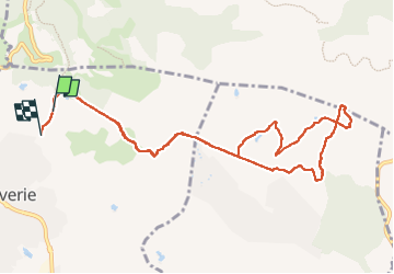

Length
11.7 km

Max alt
149 m

Uphill gradient
208 m
Km-Effort
14.5 km

Min alt
71 m

Downhill gradient
215 m
Boucle
No
Creation date :
2022-10-13 06:52:15.775
Updated on :
2022-10-13 10:11:54.563
2h42
Difficulty : Very easy

FREE GPS app for hiking
 SityTrail
IGN / Geographical institutes
SityTrail Plus
The world is yours!
About
Trail Walking of 11.7 km to be discovered at Provence-Alpes-Côte d'Azur, Var, Roquebrune-sur-Argens. This trail is proposed by Michel DUBOIS.
Positioning
Country:
France
Region :
Provence-Alpes-Côte d'Azur
Department/Province :
Var
Municipality :
Roquebrune-sur-Argens
Location:
Unknown
Start:(Dec)
Start:(UTM)
310383 ; 4820163 (32T) N.
Comments