


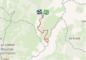
Lac Charvin

LUCIE2016
User

Length
12 km

Max alt
2092 m

Uphill gradient
937 m
Km-Effort
25 km

Min alt
1172 m

Downhill gradient
940 m
Boucle
Yes
Creation date :
2022-10-13 19:05:45.527
Updated on :
2022-10-13 19:06:44.618
5h34
Difficulty : Very difficult

FREE GPS app for hiking
 SityTrail
IGN / Geographical institutes
SityTrail Plus
The world is yours!
About
Trail Walking of 12 km to be discovered at Auvergne-Rhône-Alpes, Upper Savoy, Manigod. This trail is proposed by LUCIE2016.
Positioning
Country:
France
Region :
Auvergne-Rhône-Alpes
Department/Province :
Upper Savoy
Municipality :
Manigod
Location:
Unknown
Start:(Dec)
Start:(UTM)
299453 ; 5078534 (32T) N.
Comments