


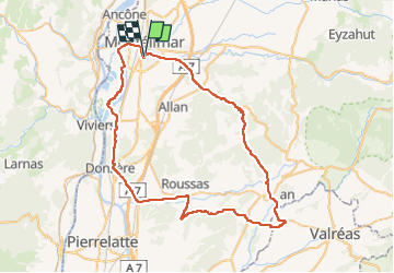
Montélimar-Colombier Grignan Donzère 70km

thonyc
User GUIDE

Length
70 km

Max alt
439 m

Uphill gradient
929 m
Km-Effort
83 km

Min alt
60 m

Downhill gradient
931 m
Boucle
Yes
Creation date :
2022-10-15 08:42:53.24
Updated on :
2022-10-15 08:54:51.641
0m
Difficulty : Medium

FREE GPS app for hiking
 SityTrail
IGN / Geographical institutes
SityTrail Plus
The world is yours!
About
Trail Cycle of 70 km to be discovered at Auvergne-Rhône-Alpes, Drôme, Montélimar. This trail is proposed by thonyc.
Positioning
Country:
France
Region :
Auvergne-Rhône-Alpes
Department/Province :
Drôme
Municipality :
Montélimar
Location:
Unknown
Start:(Dec)
Start:(UTM)
639194 ; 4933915 (31T) N.
Comments