


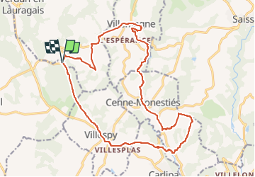
essai secteur st papoul sud et est

leroj73
User

Length
21 km

Max alt
422 m

Uphill gradient
438 m
Km-Effort
27 km

Min alt
156 m

Downhill gradient
438 m
Boucle
Yes
Creation date :
2022-10-15 18:17:25.794
Updated on :
2022-10-15 18:17:27.845
1h53
Difficulty : Medium

FREE GPS app for hiking
 SityTrail
IGN / Geographical institutes
SityTrail Plus
The world is yours!
About
Trail Mountain bike of 21 km to be discovered at Occitania, Aude, Verdun-en-Lauragais. This trail is proposed by leroj73.
Positioning
Country:
France
Region :
Occitania
Department/Province :
Aude
Municipality :
Verdun-en-Lauragais
Location:
Unknown
Start:(Dec)
Start:(UTM)
425360 ; 4799543 (31T) N.
Comments
petite ballade sympa avec Zéro difficulté. en famille. ponctuée par la cueillette de cèpes et coprins chevelus