


circuit chanterelles

Titinechris
User
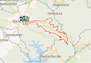

Length
16.3 km

Max alt
532 m

Uphill gradient
378 m
Km-Effort
21 km

Min alt
316 m

Downhill gradient
374 m
Boucle
No
Creation date :
2022-10-16 07:11:47.06
Updated on :
2022-10-16 07:13:14.312
0m
Difficulty : Easy

FREE GPS app for hiking
 SityTrail
IGN / Geographical institutes
SityTrail Plus
The world is yours!
About
Trail Running of 16.3 km to be discovered at Grand Est, Meurthe-et-Moselle, Badonviller. This trail is proposed by Titinechris.
Positioning
Country:
France
Region :
Grand Est
Department/Province :
Meurthe-et-Moselle
Municipality :
Badonviller
Location:
Unknown
Start:(Dec)
Start:(UTM)
344501 ; 5373736 (32U) N.
Comments