


Chantemerle les blés

alinetpierre
User

Length
13.2 km

Max alt
280 m

Uphill gradient
270 m
Km-Effort
16.8 km

Min alt
190 m

Downhill gradient
270 m
Boucle
Yes
Creation date :
2022-10-16 06:18:59.0
Updated on :
2022-10-16 08:58:35.367
2h31
Difficulty : Easy

FREE GPS app for hiking
 SityTrail
IGN / Geographical institutes
SityTrail Plus
The world is yours!
About
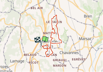
Trail Walking of 13.2 km to be discovered at Auvergne-Rhône-Alpes, Drôme, Chantemerle-les-Blés. This trail is proposed by alinetpierre.
Description
Randonnée scolaire du 16 octobre 2022
Positioning
Country:
France
Region :
Auvergne-Rhône-Alpes
Department/Province :
Drôme
Municipality :
Chantemerle-les-Blés
Location:
Unknown
Start:(Dec)
Start:(UTM)
648827 ; 4996964 (31T) N.
Comments