le Mulerthael

micheldutilleul
User
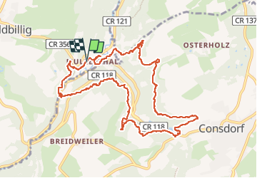

Length
12 km

Max alt
355 m

Uphill gradient
318 m
Km-Effort
16.2 km

Min alt
211 m

Downhill gradient
319 m
Boucle
Yes
Creation date :
2022-10-15 08:08:56.99
Updated on :
2022-10-16 14:03:59.216
3h30
Difficulty : Medium

FREE GPS app for hiking
 SityTrail
IGN / Geographical institutes
SityTrail Plus
The world is yours!
About
Trail Walking of 12 km to be discovered at Unknown, Canton Echternach, Waldbillig. This trail is proposed by micheldutilleul.
Description
Magnifique balade dans les bois ( rocher, cascade, passage dans la roche,...).
Attention, chemins glissant par temps de pluie, bonnes chaussures de marché conseillées.
Positioning
Country:
Luxembourg
Region :
Unknown
Department/Province :
Canton Echternach
Municipality :
Waldbillig
Location:
Unknown
Start:(Dec)
Start:(UTM)
306078 ; 5518789 (32U) N.
Comments