


mulhertael, route 2

micheldutilleul
User
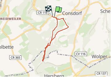

Length
5.7 km

Max alt
365 m

Uphill gradient
108 m
Km-Effort
7.2 km

Min alt
293 m

Downhill gradient
121 m
Boucle
Yes
Creation date :
2022-10-15 12:26:19.705
Updated on :
2022-10-16 14:04:01.74
1h30
Difficulty : Medium

FREE GPS app for hiking
 SityTrail
IGN / Geographical institutes
SityTrail Plus
The world is yours!
About
Trail Walking of 5.7 km to be discovered at Unknown, Canton Echternach, Consdorf. This trail is proposed by micheldutilleul.
Description
De beaux passages dans la crevasse sombre de Kuelscheier.
Attention glissant par temps de pluie.
Positioning
Country:
Luxembourg
Region :
Unknown
Department/Province :
Canton Echternach
Municipality :
Consdorf
Location:
Unknown
Start:(Dec)
Start:(UTM)
307668 ; 5517441 (32U) N.
Comments