


Beaufort

micheldutilleul
User
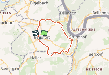

Length
12.8 km

Max alt
394 m

Uphill gradient
302 m
Km-Effort
16.8 km

Min alt
252 m

Downhill gradient
302 m
Boucle
Yes
Creation date :
2022-10-16 10:01:58.14
Updated on :
2022-10-16 14:04:05.557
3h15
Difficulty : Medium

FREE GPS app for hiking
 SityTrail
IGN / Geographical institutes
SityTrail Plus
The world is yours!
About
Trail Walking of 12.8 km to be discovered at Unknown, Canton Echternach, Beaufort. This trail is proposed by micheldutilleul.
Description
Belle balade, au départ du château de Beaufort. Possibilité de visiter les ruines du château.
Une partie le long de la rivière.
Positioning
Country:
Luxembourg
Region :
Unknown
Department/Province :
Canton Echternach
Municipality :
Beaufort
Location:
Unknown
Start:(Dec)
Start:(UTM)
304955 ; 5523613 (32U) N.
Comments