


casterino de St dalmas de tende

franquen
User
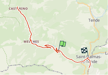

Length
24 km

Max alt
1559 m

Uphill gradient
662 m
Km-Effort
34 km

Min alt
656 m

Downhill gradient
946 m
Boucle
No
Creation date :
2022-10-17 13:04:25.927
Updated on :
2022-10-17 15:24:57.232
2h20
Difficulty : Difficult

FREE GPS app for hiking
 SityTrail
IGN / Geographical institutes
SityTrail Plus
The world is yours!
About
Trail Mountain bike of 24 km to be discovered at Provence-Alpes-Côte d'Azur, Maritime Alps, Tende. This trail is proposed by franquen.
Positioning
Country:
France
Region :
Provence-Alpes-Côte d'Azur
Department/Province :
Maritime Alps
Municipality :
Tende
Location:
Unknown
Start:(Dec)
Start:(UTM)
384094 ; 4879993 (32T) N.
Comments