


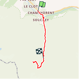
champhorent-lac des bêches-refuge de la lavey

maupassant38
User

Length
10.2 km

Max alt
2408 m

Uphill gradient
999 m
Km-Effort
23 km

Min alt
1429 m

Downhill gradient
776 m
Boucle
No
Creation date :
2019-02-22 22:31:59.844
Updated on :
2019-02-22 22:31:59.854
4h36
Difficulty : Medium

FREE GPS app for hiking
 SityTrail
IGN / Geographical institutes
SityTrail Plus
The world is yours!
About
Trail Walking of 10.2 km to be discovered at Auvergne-Rhône-Alpes, Isère, Saint-Christophe-en-Oisans. This trail is proposed by maupassant38.
Positioning
Country:
France
Region :
Auvergne-Rhône-Alpes
Department/Province :
Isère
Municipality :
Saint-Christophe-en-Oisans
Location:
Unknown
Start:(Dec)
Start:(UTM)
279055 ; 4979621 (32T) N.
Comments