


Pradelles Langogne Trottinette

Spinnaker
User
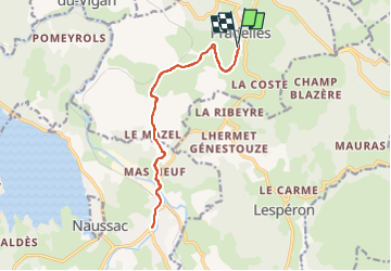

Length
15.5 km

Max alt
1137 m

Uphill gradient
326 m
Km-Effort
19.8 km

Min alt
899 m

Downhill gradient
334 m
Boucle
Yes
Creation date :
2022-10-19 13:32:15.004
Updated on :
2022-10-19 15:36:57.063
45m
Difficulty : Very easy

FREE GPS app for hiking
 SityTrail
IGN / Geographical institutes
SityTrail Plus
The world is yours!
About
Trail Electric bike of 15.5 km to be discovered at Auvergne-Rhône-Alpes, Haute-Loire, Pradelles. This trail is proposed by Spinnaker.
Positioning
Country:
France
Region :
Auvergne-Rhône-Alpes
Department/Province :
Haute-Loire
Municipality :
Pradelles
Location:
Unknown
Start:(Dec)
Start:(UTM)
569854 ; 4957548 (31T) N.
Comments