


CDP RANDO BEAUJOLAIS 2022

dehemjacques
User
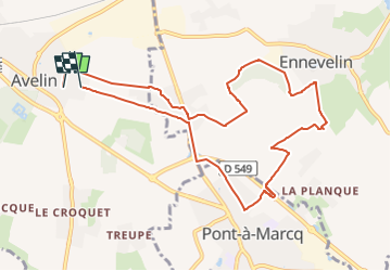

Length
9.4 km

Max alt
38 m

Uphill gradient
37 m
Km-Effort
9.9 km

Min alt
26 m

Downhill gradient
39 m
Boucle
No
Creation date :
2022-10-20 14:22:10.072
Updated on :
2022-10-20 14:22:14.417
2h15
Difficulty : Medium

FREE GPS app for hiking
 SityTrail
IGN / Geographical institutes
SityTrail Plus
The world is yours!
About
Trail Walking of 9.4 km to be discovered at Hauts-de-France, Nord, Avelin. This trail is proposed by dehemjacques.
Positioning
Country:
France
Region :
Hauts-de-France
Department/Province :
Nord
Municipality :
Avelin
Location:
Unknown
Start:(Dec)
Start:(UTM)
506095 ; 5598346 (31U) N.
Comments