


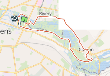
Retour par Camon et Rivery

RC76
User

Length
9 km

Max alt
34 m

Uphill gradient
50 m
Km-Effort
9.7 km

Min alt
21 m

Downhill gradient
48 m
Boucle
Yes
Creation date :
2022-10-20 14:44:01.775
Updated on :
2023-04-12 13:47:14.802
2h11
Difficulty : Medium

FREE GPS app for hiking
 SityTrail
IGN / Geographical institutes
SityTrail Plus
The world is yours!
About
Trail Walking of 9 km to be discovered at Hauts-de-France, Somme, Amiens. This trail is proposed by RC76.


Positioning
Country:
France
Region :
Hauts-de-France
Department/Province :
Somme
Municipality :
Amiens
Location:
Unknown
Start:(Dec)
Start:(UTM)
450271 ; 5527271 (31U) N.
Comments