


tôt de Ludres

Nila81
User
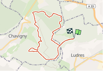

Length
9.9 km

Max alt
422 m

Uphill gradient
135 m
Km-Effort
11.7 km

Min alt
361 m

Downhill gradient
133 m
Boucle
Yes
Creation date :
2022-10-20 12:34:01.473
Updated on :
2022-10-20 15:13:08.865
2h37
Difficulty : Medium

FREE GPS app for hiking
 SityTrail
IGN / Geographical institutes
SityTrail Plus
The world is yours!
About
Trail Walking of 9.9 km to be discovered at Grand Est, Meurthe-et-Moselle, Ludres. This trail is proposed by Nila81.
Description
pas de pluie
Positioning
Country:
France
Region :
Grand Est
Department/Province :
Meurthe-et-Moselle
Municipality :
Ludres
Location:
Unknown
Start:(Dec)
Start:(UTM)
290662 ; 5390037 (32U) N.
Comments