


LA CAIRE-COMMANDERIE TOUSSIERE (PETIT CIRCUIT)

RD78-38
User
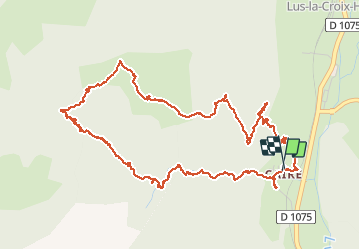

Length
7.7 km

Max alt
1277 m

Uphill gradient
313 m
Km-Effort
11.9 km

Min alt
998 m

Downhill gradient
310 m
Boucle
Yes
Creation date :
2014-12-10 00:00:00.0
Updated on :
2020-07-11 00:25:11.12
2h44
Difficulty : Easy

FREE GPS app for hiking
 SityTrail
IGN / Geographical institutes
SityTrail Plus
The world is yours!
About
Trail Walking of 7.7 km to be discovered at Auvergne-Rhône-Alpes, Drôme, Lus-la-Croix-Haute. This trail is proposed by RD78-38.
Description
Petit circuit facile sans grand intérêt : circuit pratiquement toujours en forêt sans aucune vue.
Positioning
Country:
France
Region :
Auvergne-Rhône-Alpes
Department/Province :
Drôme
Municipality :
Lus-la-Croix-Haute
Location:
Unknown
Start:(Dec)
Start:(UTM)
713479 ; 4948718 (31T) N.
Comments