


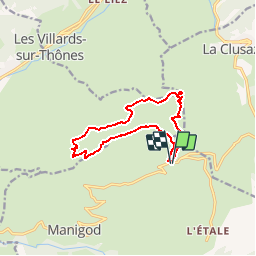
Beauregard - La Croix de Colomban - Les Frêtes

bourel.jacques
User


3h54
Difficulty : Easy

FREE GPS app for hiking
 SityTrail
IGN / Geographical institutes
SityTrail Plus
The world is yours!
About
Trail Walking of 11.6 km to be discovered at Auvergne-Rhône-Alpes, Upper Savoy, Manigod. This trail is proposed by bourel.jacques.
Description
Ballade facile avec de très belles vues sur les Aravis, les Bornes, Le Mont Blanc.
A faire par temps clair.
Il est possible d'éviter le détour par la ferme de Colomban d'en bas : après la Croix de Colomban passer à la ferme de Colomban (d'en haut) pour rejoindre le chemin qui suit la crête de "Sur les Frêtes" (Tour du Val Sulens).
Positioning
Comments
super