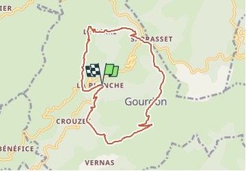
2022-10-23_11h30m21_gourdon-circuit-du-col-de-sarrasset

Linerou
User

Length
8.6 km

Max alt
875 m

Uphill gradient
287 m
Km-Effort
12.4 km

Min alt
591 m

Downhill gradient
291 m
Boucle
Yes
Creation date :
2022-10-23 09:30:21.141
Updated on :
2022-10-23 09:44:34.581
2h49
Difficulty : Medium

FREE GPS app for hiking
 SityTrail
IGN / Geographical institutes
SityTrail Plus
The world is yours!
About
Trail Walking of 8.6 km to be discovered at Auvergne-Rhône-Alpes, Ardèche, Gourdon. This trail is proposed by Linerou.
Positioning
Country:
France
Region :
Auvergne-Rhône-Alpes
Department/Province :
Ardèche
Municipality :
Gourdon
Location:
Unknown
Start:(Dec)
Start:(UTM)
614691 ; 4954141 (31T) N.
Comments