


rondelette du simanche

PhilB24
User
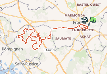

Length
26 km

Max alt
212 m

Uphill gradient
246 m
Km-Effort
29 km

Min alt
133 m

Downhill gradient
245 m
Boucle
Yes
Creation date :
2022-10-23 07:30:56.442
Updated on :
2022-10-23 09:54:59.095
2h23
Difficulty : Medium

FREE GPS app for hiking
 SityTrail
IGN / Geographical institutes
SityTrail Plus
The world is yours!
About
Trail Mountain bike of 26 km to be discovered at Occitania, Haute-Garonne, Fronton. This trail is proposed by PhilB24.
Positioning
Country:
France
Region :
Occitania
Department/Province :
Haute-Garonne
Municipality :
Fronton
Location:
Unknown
Start:(Dec)
Start:(UTM)
371398 ; 4854980 (31T) N.
Comments