


Déménagement Atlas Sauvenière

philadelphie
User
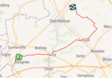

Length
21 km

Max alt
190 m

Uphill gradient
204 m
Km-Effort
24 km

Min alt
108 m

Downhill gradient
193 m
Boucle
No
Creation date :
2014-12-10 00:00:00.0
Updated on :
2014-12-10 00:00:00.0
3h26
Difficulty : Medium

FREE GPS app for hiking
 SityTrail
IGN / Geographical institutes
SityTrail Plus
The world is yours!
About
Trail Equestrian of 21 km to be discovered at Wallonia, Namur, Sombreffe. This trail is proposed by philadelphie.
Positioning
Country:
Belgium
Region :
Wallonia
Department/Province :
Namur
Municipality :
Sombreffe
Location:
Boignée
Start:(Dec)
Start:(UTM)
613148 ; 5595344 (31U) N.
Comments