


vers_piste_descente_bleue

PhilippeC54
User
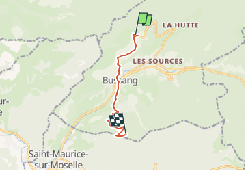

Length
7.1 km

Max alt
1010 m

Uphill gradient
415 m
Km-Effort
12.1 km

Min alt
595 m

Downhill gradient
234 m
Boucle
No
Creation date :
2022-10-25 08:00:15.502
Updated on :
2022-10-25 08:00:15.502
50m
Difficulty : Easy

FREE GPS app for hiking
 SityTrail
IGN / Geographical institutes
SityTrail Plus
The world is yours!
About
Trail Mountain bike of 7.1 km to be discovered at Grand Est, Vosges, Bussang. This trail is proposed by PhilippeC54.
Positioning
Country:
France
Region :
Grand Est
Department/Province :
Vosges
Municipality :
Bussang
Location:
Unknown
Start:(Dec)
Start:(UTM)
340318 ; 5307512 (32T) N.
Comments