Trail  Saint-Martin-en-Haut - 2022-10-25_19h37m47_les-megalithes - Photo

2022-10-25_19h37m47_les-megalithes

© OpenStreetMap contributors
Length
Length
12.7 km
Max alt
Max alt
886 m
Uphill gradient
Uphill gradient
379 m
Km-Effort
Km-Effort  
17.7 km
Min alt
Min alt
679 m
Downhill gradient
Downhill gradient
358 m
Boucle
Boucle
No
Creation date :
2022-10-25 17:37:48.11
Updated on :
2022-10-25 17:37:50.025

(0 Reviews)


Scan this QR Code to open this trail in the SityTrail application

FREE GPS app for hiking

Logo SityTrail SityTrail

IGN / Geographical institutes

Download SityTrail from the App Store Download SityTrail from Google Play

Logo SityTrail SityTrail Plus

The world is yours!

Download SityTrail from the App Store Download SityTrail from Google Play Download SityTrail on Huawei AppGallery

About

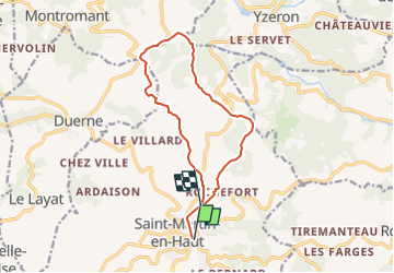
Trail of 12.7 km to be discovered at Auvergne-Rhône-Alpes, Rhône, Saint-Martin-en-Haut. This trail is proposed by JacouBrijou.

Description

En suivant le GR7 jusqu\'à la clairière des Brosses, on traverse le site médiéval de Rochefort et on pase en contre bas du dolmen du Crêt de la Poipe. Sur le retour on apperçoit la roche Girardière et la roches des Hayes (rocher en équilibre)

Elevation profile

Positioning

Country:
France
Region :
Auvergne-Rhône-Alpes
Department/Province :
Rhône
Municipality :
Saint-Martin-en-Haut
Location:
Unknown
Start:(UTM)
621905 ; 5057321 (31T) N.


Close
My subscriptions