![](/images/other/stat-length.png)
![Trail Walking Vodable - Vodable_Ronzieres - Photo](https://media.geolcdn.com/t/1900/400/ext.pjpeg?maxdim=2&url=https%3A%2F%2Fmedia.geolcdn.com%2Ff%2F212d647d-7980-4e4c-8c90-025466bfa64e.jpg)
Vodable_Ronzieres
jagarnier
User GUIDE
![Length](/images/other/stat-length.png)
Length
12.8 km
![Max alt](https://static1.geolcdn.com/siteimages/upload/files/1508320355ic_sort_altitude_max_24dp.png)
Max alt
841 m
![Uphill gradient](https://static1.geolcdn.com/siteimages/upload/files/1508320355ic_sort_den_pos_24dp.png)
Uphill gradient
392 m
![Km-Effort](/images/other/stat-length.png)
Km-Effort
18 km
![Min alt](https://static1.geolcdn.com/siteimages/upload/files/1508320355ic_sort_altitude_min_24dp.png)
Min alt
658 m
![Downhill gradient](https://static1.geolcdn.com/siteimages/upload/files/1508320355ic_sort_den_neg_24dp.png)
Downhill gradient
390 m
![Boucle](https://static1.geolcdn.com/siteimages/upload/files/16400158638029165_repeat_loop_refresh_sync_direction_icon.png)
Boucle
Yes
Creation date :
2022-10-26 12:28:42.118
Updated on :
2022-12-16 11:06:53.43
![Walking](https://static1.geolcdn.com/sitytour/trail-icons/101.png)
3h45
Difficulty : Medium
![Scan this QR Code to open this trail in the SityTrail application](https://capi.geolives.com/qq0zvz2zws4bq2lad0pu/sitytour/trails/3436144/qr.png?size=200)
FREE GPS app for hiking
About
Trail Walking of 12.8 km to be discovered at Auvergne-Rhône-Alpes, Puy-de-Dôme, Vodable. This trail is proposed by jagarnier.
Description
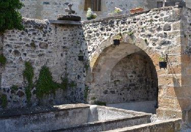
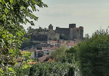
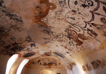
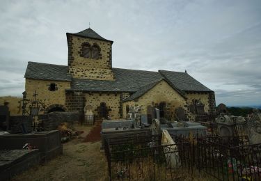
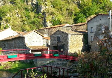
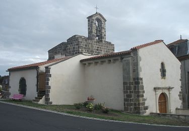
Au cœur du Lembron, terre d'anciens volcans et de coulées de lave, le village de Ronzières s'enroule autour d'une butte basaltique. Fier de son oppidum, cette place forte fut utilisée dès le premier millénaire avant notre ère.
Positioning
Country:
France
Region :
Auvergne-Rhône-Alpes
Department/Province :
Puy-de-Dôme
Municipality :
Vodable
Location:
Unknown
Start:(Dec)
Start:(UTM)
511249 ; 5039419 (31T) N.
Comments
Trails nearby
![Trail Walking Saint-Vincent - St_Vincent_Puy_Lavelle_JG_02 - Photo](https://media.geolcdn.com/t/375/260/ext.jpg?maxdim=2&url=https%3A%2F%2Fmedia.geolcdn.com%2Ff%2Fa3fc96ef-efb3-4784-a23c-0f44c0b5ca63.jpg)
![Walking Walking](https://static1.geolcdn.com/sitytour/trail-icons/101.png)
St_Vincent_Puy_Lavelle_JG_02
Walking
Medium
(2)
Saint-Vincent,
Auvergne-Rhône-Alpes,
Puy-de-Dôme,
France
![](/images/other/stat-length.png)
10.1 km | 14.9 km-effort
3h 0min
![](https://static1.geolcdn.com/siteimages/upload/files/16400158638029165_repeat_loop_refresh_sync_direction_icon.png)
Yes
![Trail On foot Boudes - Villeneuve, Boudes, Chalus - Photo](https://media.geolcdn.com/t/375/260/ext.jpg?maxdim=2&url=https%3A%2F%2Fmedia.geolcdn.com%2Ff%2F9a83dcb2-377f-43a0-8436-358d4c634f72.jpeg)
![On foot On foot](https://static1.geolcdn.com/sitytour/trail-icons/100.png)
Villeneuve, Boudes, Chalus
On foot
Easy
Boudes,
Auvergne-Rhône-Alpes,
Puy-de-Dôme,
France
![](/images/other/stat-length.png)
9 km | 13.3 km-effort
3h 0min
![](https://static1.geolcdn.com/siteimages/upload/files/16400158638029165_repeat_loop_refresh_sync_direction_icon.png)
Yes
![Trail On foot Mareugheol - La Chaux et le Bois de Jaby - Photo](https://media.geolcdn.com/t/375/260/ext.jpg?maxdim=2&url=https%3A%2F%2Fmedia.geolcdn.com%2Ff%2Fd7ed3937-d9f3-475d-9b76-187d38d4bf46.jpeg)
![On foot On foot](https://static1.geolcdn.com/sitytour/trail-icons/100.png)
La Chaux et le Bois de Jaby
On foot
Easy
Mareugheol,
Auvergne-Rhône-Alpes,
Puy-de-Dôme,
France
![](/images/other/stat-length.png)
10.1 km | 13.7 km-effort
3h 7min
![](https://static1.geolcdn.com/siteimages/upload/files/16400158638029165_repeat_loop_refresh_sync_direction_icon.png)
Yes
![Trail On foot Dauzat-sur-Vodable - Dauzat-sur-Vodable - Photo](https://media.geolcdn.com/t/375/260/ext.jpg?maxdim=2&url=https%3A%2F%2Fmedia.geolcdn.com%2Ff%2Fd172e481-65da-4881-bd03-f6cc99def315.jpeg)
![On foot On foot](https://static1.geolcdn.com/sitytour/trail-icons/100.png)
Dauzat-sur-Vodable
On foot
Easy
Dauzat-sur-Vodable,
Auvergne-Rhône-Alpes,
Puy-de-Dôme,
France
![](/images/other/stat-length.png)
10 km | 14.7 km-effort
3h 20min
![](https://static1.geolcdn.com/siteimages/upload/files/16400158638029165_repeat_loop_refresh_sync_direction_icon.png)
Yes
![Trail On foot Saint-Floret - La Chaubasse - Photo](https://media.geolcdn.com/t/375/260/ext.jpg?maxdim=2&url=https%3A%2F%2Fmedia.geolcdn.com%2Ff%2F768fec42-41d9-4005-9393-314a0342ff62.jpeg)
![On foot On foot](https://static1.geolcdn.com/sitytour/trail-icons/100.png)
La Chaubasse
On foot
Easy
Saint-Floret,
Auvergne-Rhône-Alpes,
Puy-de-Dôme,
France
![](/images/other/stat-length.png)
9.4 km | 14.2 km-effort
3h 13min
![](https://static1.geolcdn.com/siteimages/upload/files/16400158638029165_repeat_loop_refresh_sync_direction_icon.png)
Yes
![Trail On foot Villeneuve - Vodable et Colamine - Photo](https://media.geolcdn.com/t/375/260/ext.jpg?maxdim=2&url=https%3A%2F%2Fmedia.geolcdn.com%2Ff%2Ffd9aa514-9038-4f51-9473-e7a8f5ea4688.jpeg)
![On foot On foot](https://static1.geolcdn.com/sitytour/trail-icons/100.png)
Vodable et Colamine
On foot
Easy
Villeneuve,
Auvergne-Rhône-Alpes,
Puy-de-Dôme,
France
![](/images/other/stat-length.png)
12 km | 16.6 km-effort
3h 45min
![](https://static1.geolcdn.com/siteimages/upload/files/16400158638029165_repeat_loop_refresh_sync_direction_icon.png)
No
![Trail On foot Tourzel-Ronzières - Les Cinq Villages - Photo](https://media.geolcdn.com/t/375/260/ext.jpg?maxdim=2&url=https%3A%2F%2Fmedia.geolcdn.com%2Ff%2F3398564d-d4fb-4353-84f0-628dcc0a106c.jpeg)
![On foot On foot](https://static1.geolcdn.com/sitytour/trail-icons/100.png)
Les Cinq Villages
On foot
Easy
Tourzel-Ronzières,
Auvergne-Rhône-Alpes,
Puy-de-Dôme,
France
![](/images/other/stat-length.png)
13.2 km | 18.3 km-effort
4h 9min
![](https://static1.geolcdn.com/siteimages/upload/files/16400158638029165_repeat_loop_refresh_sync_direction_icon.png)
Yes
![Trail On foot Solignat - Le Puy d'Ysson - Photo](https://media.geolcdn.com/t/375/260/ext.jpg?maxdim=2&url=https%3A%2F%2Fmedia.geolcdn.com%2Ff%2Ff1717d1b-4654-496b-985d-41ee86c18055.jpeg)
![On foot On foot](https://static1.geolcdn.com/sitytour/trail-icons/100.png)
Le Puy d'Ysson
On foot
Easy
Solignat,
Auvergne-Rhône-Alpes,
Puy-de-Dôme,
France
![](/images/other/stat-length.png)
6.8 km | 9.6 km-effort
2h 10min
![](https://static1.geolcdn.com/siteimages/upload/files/16400158638029165_repeat_loop_refresh_sync_direction_icon.png)
No
![Trail On foot Perrier - Chaux de Pardines et Grottes de Perrier - Photo](https://media.geolcdn.com/t/375/260/ext.jpg?maxdim=2&url=https%3A%2F%2Fmedia.geolcdn.com%2Ff%2Fab740f7c-222b-48b5-9ed1-765843646dcc.jpeg)
![On foot On foot](https://static1.geolcdn.com/sitytour/trail-icons/100.png)
Chaux de Pardines et Grottes de Perrier
On foot
Easy
Perrier,
Auvergne-Rhône-Alpes,
Puy-de-Dôme,
France
![](/images/other/stat-length.png)
12 km | 15.6 km-effort
3h 33min
![](https://static1.geolcdn.com/siteimages/upload/files/16400158638029165_repeat_loop_refresh_sync_direction_icon.png)
Yes