


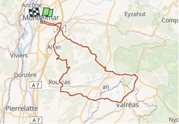
Montélimar-Taulignan-Grillon 79km

thonyc
User GUIDE

Length
79 km

Max alt
434 m

Uphill gradient
1003 m
Km-Effort
93 km

Min alt
84 m

Downhill gradient
1005 m
Boucle
Yes
Creation date :
2022-10-26 11:28:04.218
Updated on :
2022-10-27 06:57:09.962
4h00
Difficulty : Medium

FREE GPS app for hiking
 SityTrail
IGN / Geographical institutes
SityTrail Plus
The world is yours!
About
Trail Road bike of 79 km to be discovered at Auvergne-Rhône-Alpes, Drôme, Montélimar. This trail is proposed by thonyc.
Positioning
Country:
France
Region :
Auvergne-Rhône-Alpes
Department/Province :
Drôme
Municipality :
Montélimar
Location:
Unknown
Start:(Dec)
Start:(UTM)
639194 ; 4933923 (31T) N.
Comments