


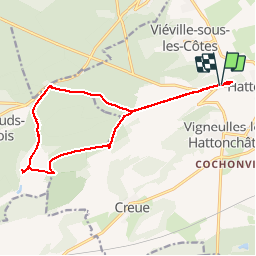
Abbaye de l'Etanche depuis Hattonchatel

kikkko
User

Length
14.5 km

Max alt
414 m

Uphill gradient
245 m
Km-Effort
17.8 km

Min alt
273 m

Downhill gradient
246 m
Boucle
Yes
Creation date :
2014-12-10 00:00:00.0
Updated on :
2014-12-10 00:00:00.0
1h52
Difficulty : Medium

FREE GPS app for hiking
 SityTrail
IGN / Geographical institutes
SityTrail Plus
The world is yours!
About
Trail Mountain bike of 14.5 km to be discovered at Grand Est, Meuse, Vigneulles-lès-Hattonchâtel. This trail is proposed by kikkko.
Positioning
Country:
France
Region :
Grand Est
Department/Province :
Meuse
Municipality :
Vigneulles-lès-Hattonchâtel
Location:
Hattonchâtel
Start:(Dec)
Start:(UTM)
697620 ; 5430097 (31U) N.
Comments