


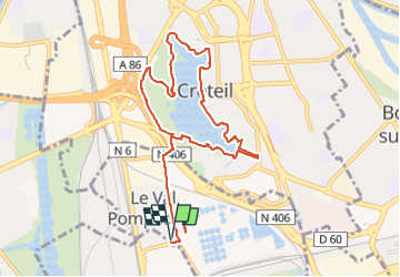
Tour Lac Créteil 10km

jeanmarcMasson
User GUIDE

Length
9.6 km

Max alt
64 m

Uphill gradient
88 m
Km-Effort
10.7 km

Min alt
28 m

Downhill gradient
88 m
Boucle
Yes
Creation date :
2022-10-29 12:37:09.556
Updated on :
2022-10-29 12:41:55.096
2h26
Difficulty : Medium

FREE GPS app for hiking
 SityTrail
IGN / Geographical institutes
SityTrail Plus
The world is yours!
About
Trail Walking of 9.6 km to be discovered at Ile-de-France, Val-de-Marne, Valenton. This trail is proposed by jeanmarcMasson.
Positioning
Country:
France
Region :
Ile-de-France
Department/Province :
Val-de-Marne
Municipality :
Valenton
Location:
Unknown
Start:(Dec)
Start:(UTM)
459424 ; 5401127 (31U) N.
Comments