


2022-10-30_15h17m45_Zepp20221030133802

raab
User
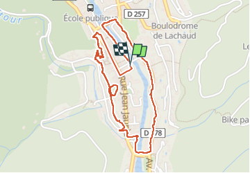

Length
2.7 km

Max alt
273 m

Uphill gradient
28 m
Km-Effort
3 km

Min alt
248 m

Downhill gradient
29 m
Boucle
Yes
Creation date :
2022-10-30 14:17:46.415
Updated on :
2022-10-30 14:26:46.517
41m
Difficulty : Easy

FREE GPS app for hiking
 SityTrail
IGN / Geographical institutes
SityTrail Plus
The world is yours!
About
Trail Walking of 2.7 km to be discovered at Auvergne-Rhône-Alpes, Ardèche, Vals-les-Bains. This trail is proposed by raab.
Positioning
Country:
France
Region :
Auvergne-Rhône-Alpes
Department/Province :
Ardèche
Municipality :
Vals-les-Bains
Location:
Unknown
Start:(Dec)
Start:(UTM)
608353 ; 4946497 (31T) N.
Comments