


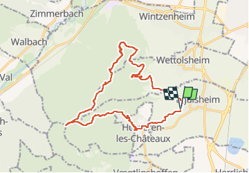
Rando des cinq châteaux

Ko-Rando
User

Length
18.4 km

Max alt
747 m

Uphill gradient
730 m
Km-Effort
28 km

Min alt
220 m

Downhill gradient
726 m
Boucle
Yes
Creation date :
2022-10-30 08:53:20.488
Updated on :
2022-10-30 15:07:08.264
5h19
Difficulty : Medium

FREE GPS app for hiking
 SityTrail
IGN / Geographical institutes
SityTrail Plus
The world is yours!
About
Trail Walking of 18.4 km to be discovered at Grand Est, Haut-Rhin, Eguisheim. This trail is proposed by Ko-Rando.
Description
Superbe rando. Sentiers faciles, pas trop escarpés.
Photos


25 photos in total. Please click on a photo to see them all in the gallery.
Positioning
Country:
France
Region :
Grand Est
Department/Province :
Haut-Rhin
Municipality :
Eguisheim
Location:
Unknown
Start:(Dec)
Start:(UTM)
373242 ; 5322337 (32U) N.
Comments