


Marche

PhilippeC54
User
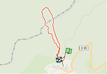

Length
3.3 km

Max alt
1013 m

Uphill gradient
168 m
Km-Effort
5.7 km

Min alt
818 m

Downhill gradient
215 m
Boucle
Yes
Creation date :
2022-10-31 13:30:44.367
Updated on :
2022-10-31 15:20:12.594
1h25
Difficulty : Easy

FREE GPS app for hiking
 SityTrail
IGN / Geographical institutes
SityTrail Plus
The world is yours!
About
Trail Walking of 3.3 km to be discovered at Grand Est, Vosges, Bussang. This trail is proposed by PhilippeC54.
Positioning
Country:
France
Region :
Grand Est
Department/Province :
Vosges
Municipality :
Bussang
Location:
Unknown
Start:(Dec)
Start:(UTM)
340520 ; 5307694 (32T) N.
Comments