


Montélimar-Mirmande-Marsanne 55km

thonyc
User GUIDE
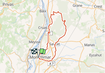

Length
57 km

Max alt
519 m

Uphill gradient
830 m
Km-Effort
68 km

Min alt
75 m

Downhill gradient
830 m
Boucle
Yes
Creation date :
2022-11-03 07:41:14.197
Updated on :
2022-11-03 07:47:38.185
0m
Difficulty : Medium

FREE GPS app for hiking
 SityTrail
IGN / Geographical institutes
SityTrail Plus
The world is yours!
About
Trail Cycle of 57 km to be discovered at Auvergne-Rhône-Alpes, Drôme, Montélimar. This trail is proposed by thonyc.
Positioning
Country:
France
Region :
Auvergne-Rhône-Alpes
Department/Province :
Drôme
Municipality :
Montélimar
Location:
Unknown
Start:(Dec)
Start:(UTM)
638504 ; 4934945 (31T) N.
Comments