


Sortie Chaussitre

ramsay
User

Length
52 km

Max alt
1239 m

Uphill gradient
1299 m
Km-Effort
69 km

Min alt
917 m

Downhill gradient
1300 m
Boucle
Yes
Creation date :
2018-04-14 00:00:00.0
Updated on :
2018-04-14 00:00:00.0
3h49
Difficulty : Difficult

FREE GPS app for hiking
 SityTrail
IGN / Geographical institutes
SityTrail Plus
The world is yours!
About
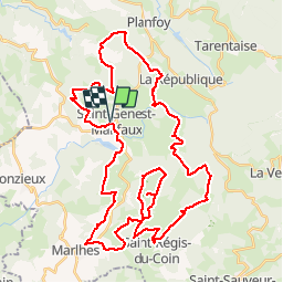
Trail Cycle of 52 km to be discovered at Auvergne-Rhône-Alpes, Loire, Saint-Genest-Malifaux. This trail is proposed by ramsay.
Description
Départ depuis St Genest Malifaux
Positioning
Country:
France
Region :
Auvergne-Rhône-Alpes
Department/Province :
Loire
Municipality :
Saint-Genest-Malifaux
Location:
Unknown
Start:(Dec)
Start:(UTM)
611042 ; 5021647 (31T) N.
Comments