


Gd Rocher

ranchoup
User
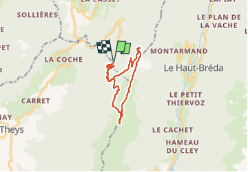

Length
12.3 km

Max alt
1915 m

Uphill gradient
521 m
Km-Effort
19.3 km

Min alt
1426 m

Downhill gradient
529 m
Boucle
Yes
Creation date :
2022-11-07 08:37:55.307
Updated on :
2022-11-07 18:52:38.93
5h49
Difficulty : Medium

FREE GPS app for hiking
 SityTrail
IGN / Geographical institutes
SityTrail Plus
The world is yours!
About
Trail Walking of 12.3 km to be discovered at Auvergne-Rhône-Alpes, Isère, Crêts-en-Belledonne. This trail is proposed by ranchoup.
Positioning
Country:
France
Region :
Auvergne-Rhône-Alpes
Department/Province :
Isère
Municipality :
Crêts-en-Belledonne
Location:
Saint-Pierre-d'Allevard
Start:(Dec)
Start:(UTM)
268581 ; 5023277 (32T) N.
Comments