


Montenvers /plan de l'aiguille ->aiguille du midi

Laurence Lallemand
User
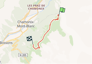

Length
7.5 km

Max alt
2316 m

Uphill gradient
581 m
Km-Effort
14.2 km

Min alt
1906 m

Downhill gradient
283 m
Boucle
No
Creation date :
2022-11-07 21:16:40.085
Updated on :
2022-11-07 21:16:41.856
3h13
Difficulty : Difficult

FREE GPS app for hiking
 SityTrail
IGN / Geographical institutes
SityTrail Plus
The world is yours!
About
Trail Walking of 7.5 km to be discovered at Auvergne-Rhône-Alpes, Upper Savoy, Chamonix-Mont-Blanc. This trail is proposed by Laurence Lallemand.
Positioning
Country:
France
Region :
Auvergne-Rhône-Alpes
Department/Province :
Upper Savoy
Municipality :
Chamonix-Mont-Blanc
Location:
Unknown
Start:(Dec)
Start:(UTM)
338547 ; 5088617 (32T) N.
Comments