Trail Walking Veynes - Boucle par la cime de Pignerol - Photo

Boucle par la cime de Pignerol

 rigol05
rigol05

User

© OpenStreetMap contributors
Length
Length
8.4 km
Max alt
Max alt
1424 m
Uphill gradient
Uphill gradient
430 m
Km-Effort
Km-Effort  
14.1 km
Min alt
Min alt
1009 m
Downhill gradient
Downhill gradient
435 m
Boucle
Boucle
Yes
Creation date :
2022-11-08 12:35:27.57
Updated on :
2022-11-29 17:11:44.313

(0 Reviews)

Walking
Walking
3h12
Difficulty : Medium

Scan this QR Code to open this trail in the SityTrail application

FREE GPS app for hiking

Logo SityTrail SityTrail

IGN / Geographical institutes

Download SityTrail from the App Store Download SityTrail from Google Play

Logo SityTrail SityTrail Plus

The world is yours!

Download SityTrail from the App Store Download SityTrail from Google Play Download SityTrail on Huawei AppGallery

About

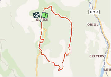
Trail Walking of 8.4 km to be discovered at Provence-Alpes-Côte d'Azur, Hautes-Alpes, Veynes. This trail is proposed by rigol05.

Description

Sortie du 8/11/2022 au départ du hameau de Glaise.
Le sens de l'itinéraire du jour impose une fin de randonnée par 1,5km de monté. Dans ce cas un départ au niveau des Pascaux est préférable. Inverser le sens permet de terminer en descente, l'ascension  jusqu'au col de Pierrefeu est plus longue.

Elevation profile

Positioning

Country:
France
Region :
Provence-Alpes-Côte d'Azur
Department/Province :
Hautes-Alpes
Municipality :
Veynes
Location:
Unknown
Start:(UTM)
724252 ; 4939487 (31T) N.


Close
My subscriptions