


pont de moulinas

panetJeanLuc
User

Length
15.7 km

Max alt
650 m

Uphill gradient
694 m
Km-Effort
25 km

Min alt
257 m

Downhill gradient
698 m
Boucle
Yes
Creation date :
2022-11-10 08:23:27.188
Updated on :
2022-11-10 15:28:54.747
3h09
Difficulty : Very difficult

FREE GPS app for hiking
 SityTrail
IGN / Geographical institutes
SityTrail Plus
The world is yours!
About
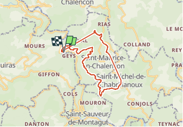
Trail Walking of 15.7 km to be discovered at Auvergne-Rhône-Alpes, Ardèche, Saint-Maurice-en-Chalencon. This trail is proposed by panetJeanLuc.
Positioning
Country:
France
Region :
Auvergne-Rhône-Alpes
Department/Province :
Ardèche
Municipality :
Saint-Maurice-en-Chalencon
Location:
Unknown
Start:(Dec)
Start:(UTM)
623575 ; 4967840 (31T) N.
Comments