


Banneville sur ajon

jacqueline L
User
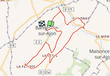

Length
10.9 km

Max alt
170 m

Uphill gradient
160 m
Km-Effort
13 km

Min alt
92 m

Downhill gradient
161 m
Boucle
Yes
Creation date :
2022-11-10 12:51:50.0
Updated on :
2022-11-10 16:13:50.778
3h21
Difficulty : Difficult

FREE GPS app for hiking
 SityTrail
IGN / Geographical institutes
SityTrail Plus
The world is yours!
About
Trail Walking of 10.9 km to be discovered at Normandy, Calvados, Malherbe-sur-Ajon. This trail is proposed by jacqueline L.
Positioning
Country:
France
Region :
Normandy
Department/Province :
Calvados
Municipality :
Malherbe-sur-Ajon
Location:
Unknown
Start:(Dec)
Start:(UTM)
677527 ; 5437350 (30U) N.
Comments