


Col de la Cochette

bourel.jacques
User
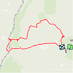

Length
9 km

Max alt
1442 m

Uphill gradient
579 m
Km-Effort
16.7 km

Min alt
888 m

Downhill gradient
579 m
Boucle
Yes
Creation date :
2016-05-19 00:00:00.0
Updated on :
2016-05-19 00:00:00.0
3h26
Difficulty : Easy

FREE GPS app for hiking
 SityTrail
IGN / Geographical institutes
SityTrail Plus
The world is yours!
About
Trail Walking of 9 km to be discovered at Auvergne-Rhône-Alpes, Savoy, Arith. This trail is proposed by bourel.jacques.
Positioning
Country:
France
Region :
Auvergne-Rhône-Alpes
Department/Province :
Savoy
Municipality :
Arith
Location:
Unknown
Start:(Dec)
Start:(UTM)
271656 ; 5066476 (32T) N.
Comments
Balade en forêt sympa et vue sur aix et son lac
Petite baladounette très sympa !