


chateauneuf de randon

ajasse
User
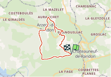

Length
14.1 km

Max alt
1381 m

Uphill gradient
377 m
Km-Effort
19.2 km

Min alt
1150 m

Downhill gradient
376 m
Boucle
Yes
Creation date :
2022-11-12 08:21:03.614
Updated on :
2022-11-12 14:35:00.378
4h11
Difficulty : Easy

FREE GPS app for hiking
 SityTrail
IGN / Geographical institutes
SityTrail Plus
The world is yours!
About
Trail Walking of 14.1 km to be discovered at Occitania, Lozère, Arzenc-de-Randon. This trail is proposed by ajasse.
Positioning
Country:
France
Region :
Occitania
Department/Province :
Lozère
Municipality :
Arzenc-de-Randon
Location:
Unknown
Start:(Dec)
Start:(UTM)
552356 ; 4943232 (31T) N.
Comments