


Puvenelle et Bois le Prêtre

PhilippeC54
User
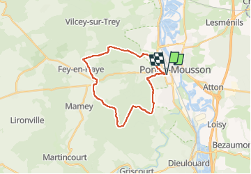

Length
23 km

Max alt
378 m

Uphill gradient
410 m
Km-Effort
28 km

Min alt
178 m

Downhill gradient
410 m
Boucle
Yes
Creation date :
2022-11-12 12:38:47.738
Updated on :
2022-11-12 15:01:45.931
2h03
Difficulty : Medium

FREE GPS app for hiking
 SityTrail
IGN / Geographical institutes
SityTrail Plus
The world is yours!
About
Trail Mountain bike of 23 km to be discovered at Grand Est, Meurthe-et-Moselle, Pont-à-Mousson. This trail is proposed by PhilippeC54.
Positioning
Country:
France
Region :
Grand Est
Department/Province :
Meurthe-et-Moselle
Municipality :
Pont-à-Mousson
Location:
Unknown
Start:(Dec)
Start:(UTM)
283572 ; 5420471 (32U) N.
Comments