


Trou de fer forêt de Bélouve

inesmyt
User
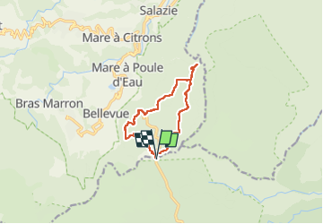

Length
14.9 km

Max alt
1616 m

Uphill gradient
365 m
Km-Effort
19.7 km

Min alt
1350 m

Downhill gradient
364 m
Boucle
Yes
Creation date :
2022-10-06 04:47:23.0
Updated on :
2022-11-12 15:21:47.981
5h18
Difficulty : Difficult

FREE GPS app for hiking
 SityTrail
IGN / Geographical institutes
SityTrail Plus
The world is yours!
About
Trail Walking of 14.9 km to be discovered at Réunion, Unknown, Saint-Benoît. This trail is proposed by inesmyt.
Positioning
Country:
France
Region :
Réunion
Department/Province :
Unknown
Municipality :
Saint-Benoît
Location:
Unknown
Start:(Dec)
Start:(UTM)
348648 ; 7668544 (40K) S.
Comments