


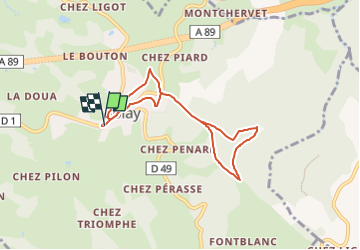
Amicale_Tour_Matagrin

d.rognon
User

Length
6.7 km

Max alt
1000 m

Uphill gradient
224 m
Km-Effort
9.7 km

Min alt
806 m

Downhill gradient
225 m
Boucle
Yes
Creation date :
2022-11-13 09:49:15.003
Updated on :
2024-10-21 15:28:57.684
2h12
Difficulty : Medium

FREE GPS app for hiking
 SityTrail
IGN / Geographical institutes
SityTrail Plus
The world is yours!
About
Trail Walking of 6.7 km to be discovered at Auvergne-Rhône-Alpes, Loire, Violay. This trail is proposed by d.rognon.
Description
Randonnée effectuée le 15/11/22
Positioning
Country:
France
Region :
Auvergne-Rhône-Alpes
Department/Province :
Loire
Municipality :
Violay
Location:
Unknown
Start:(Dec)
Start:(UTM)
605105 ; 5078399 (31T) N.
Comments