


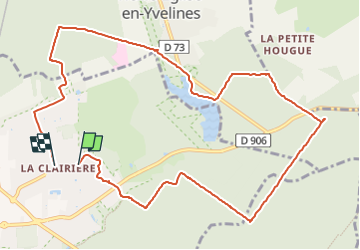
autour de la clairière

natsukeru
User

Length
11.3 km

Max alt
188 m

Uphill gradient
81 m
Km-Effort
12.4 km

Min alt
166 m

Downhill gradient
81 m
Boucle
No
Creation date :
2022-11-13 14:17:03.111
Updated on :
2022-11-13 15:16:05.814
58m
Difficulty : Easy

FREE GPS app for hiking
 SityTrail
IGN / Geographical institutes
SityTrail Plus
The world is yours!
About
Trail Mountain bike of 11.3 km to be discovered at Ile-de-France, Yvelines, Rambouillet. This trail is proposed by natsukeru.
Positioning
Country:
France
Region :
Ile-de-France
Department/Province :
Yvelines
Municipality :
Rambouillet
Location:
Unknown
Start:(Dec)
Start:(UTM)
416104 ; 5389352 (31U) N.
Comments