


BARON -22 15:30:53

UDGI54
User
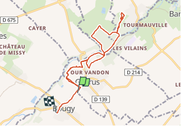

Length
8.7 km

Max alt
90 m

Uphill gradient
114 m
Km-Effort
10.2 km

Min alt
49 m

Downhill gradient
101 m
Boucle
No
Creation date :
2022-11-13 15:27:14.168
Updated on :
2022-11-13 15:27:14.168

FREE GPS app for hiking
 SityTrail
IGN / Geographical institutes
SityTrail Plus
The world is yours!
About
Trail of 8.7 km to be discovered at Normandy, Calvados, Gavrus. This trail is proposed by UDGI54.
Positioning
Country:
France
Region :
Normandy
Department/Province :
Calvados
Municipality :
Gavrus
Location:
Unknown
Start:(Dec)
Start:(UTM)
680964 ; 5443208 (30U) N.
Comments