


Villers aux Tours Adeps
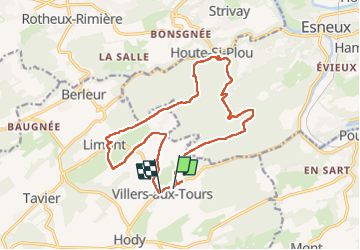
© OpenStreetMap contributors


3h17
Difficulty : Medium

0m
Difficulty : Medium


Length
15.3 km
Max alt
279 m
Uphill gradient
335 m
Km-Effort
19.8 km
Min alt
134 m
Downhill gradient
325 m
Boucle
No
Creation date :
2022-11-13 12:24:49.0
Updated on :
2022-11-13 15:51:56.701
3h17
Difficulty : Medium
0m
Difficulty : Medium
FREE GPS app for hiking
 SityTrail
IGN / Geographical institutes
SityTrail Plus
The world is yours!
About
Trail Walking of 15.3 km to be discovered at Wallonia, Liège, Anthisnes. This trail is proposed by chantal.dgdl@hotmail.com.
Description
Villers adeps 15km
Positioning
Country:
Belgium
Region :
Wallonia
Department/Province :
Liège
Municipality :
Anthisnes
Location:
Unknown
Start:(Dec)
Start:(UTM)
678462 ; 5597043 (31U) N.
Comments