


Montjavoult boucle MN Est

serge.guerroult
User
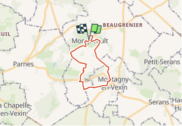

Length
9.2 km

Max alt
202 m

Uphill gradient
146 m
Km-Effort
11.2 km

Min alt
88 m

Downhill gradient
148 m
Boucle
Yes
Creation date :
2022-11-14 07:59:45.345
Updated on :
2023-07-01 17:02:34.777
1h36
Difficulty : Very easy

FREE GPS app for hiking
 SityTrail
IGN / Geographical institutes
SityTrail Plus
The world is yours!
About
Trail Nordic walking of 9.2 km to be discovered at Hauts-de-France, Oise, Montjavoult. This trail is proposed by serge.guerroult.
Photos


Positioning
Country:
France
Region :
Hauts-de-France
Department/Province :
Oise
Municipality :
Montjavoult
Location:
Unknown
Start:(Dec)
Start:(UTM)
411441 ; 5451985 (31U) N.
Comments