


chateaudouble

Lionel Gaudin
User
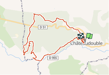

Length
12.5 km

Max alt
643 m

Uphill gradient
421 m
Km-Effort
18.1 km

Min alt
290 m

Downhill gradient
421 m
Boucle
Yes
Creation date :
2022-11-15 08:13:37.656
Updated on :
2022-11-15 14:40:15.62
3h52
Difficulty : Difficult

FREE GPS app for hiking
 SityTrail
IGN / Geographical institutes
SityTrail Plus
The world is yours!
About
Trail Walking of 12.5 km to be discovered at Provence-Alpes-Côte d'Azur, Var, Châteaudouble. This trail is proposed by Lionel Gaudin.
Positioning
Country:
France
Region :
Provence-Alpes-Côte d'Azur
Department/Province :
Var
Municipality :
Châteaudouble
Location:
Unknown
Start:(Dec)
Start:(UTM)
294206 ; 4830234 (32T) N.
Comments